TOUR & TRAVEL
On whatever trip you take, in whichever direction, there will be marvellous scenery. To the north on the Historic Route particularly around the Simien Mountains and the Gheralta and Tembien areas of Tigray, where the dramatic mountain scenery hosts exquisite rock hewn churches and monasteries.
South of Addis Ababa there is a string of seven lakes along the floor of the Rift Valley – Lakes Zwai, Langano, Abiata, Shalla, Awassa, Abaya and Chamo – each in some way different from the other. East of Awassa is the Bale Mountains National Park, (see 2b above). A trip to Bale could include the underwater river and cave system of Sof Omar, the longest in the world. South of Awassa the road passes through coffee plantations before reaching the more arid, acacia forested areas of Borana. In the west, on the road from Jimma to Gambella, there are vast stretches of tropical rain forest, while Gambella itself with its Nilotic ethnic groups provides a taste of the vast swamps and savannah of southern Sudan.
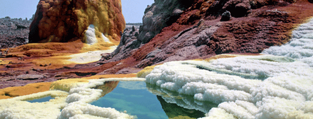
70 km south of Addis Ababa the road forks, to the east is the Afar Region and the Awash River valley, Dire Dawa and the walled city of Harer (to the south are the Rift Valley Lakes and Kenya). After Awash town some 230 kms from Addis Ababa, the road forks again, with the north east fork leading to Hadar, Yangudi Rassa Park, Aissayta and the lakes into which the Awash River drains. North of Aissayta there is Lake Afdera, or the Great Salt Lake, Mount Ert’ale, the only volcano in the world with a permanent lava lake, while further north still lies the Danakil Depression and Dalol, the lowest point below sea level on earth, with its amazing mineral formations, comprising every color of the rainbow. Travellers taking this route to the Depression could ascend the escarpment to Mekele in Tigray.
The eastern fork takes you to the Din Din forest, Dire Dawa, Harer, and for the intrepid traveler, the Somali Region.